Mt. Hakusan (Hakusan)
Mt. Hakusan is a sacred peak counted among Japan’s Three Holy Mountains alongside Mt. Fuji and Mt. Tateyama. Centered on Mt. Gozen (2,702 meters) as its highest peak, it is an active volcano that spreads around the three main summits of Hakusan—Mt. Gozen, Mt. Onanjimine, and Mt. Kengamine. Straddling the border between Shirakawa Village in Ono District, Gifu Prefecture, and Hakusan City in Ishikawa Prefecture, the entire mountain is designated as a national park, preserving its rich natural environment. Covered in snow for more than half the year, it has long been known as “the White Peak of Koshi” and has been revered by people since ancient times.
Mt. Hakusan’s present form was shaped by repeated volcanic eruptions beginning around 400,000 years ago. The Hakusan volcanic complex is composed mainly of three volcanic bodies of different ages: the Kaga-Muro Volcano (approximately 430,000–250,000 years ago), the Old Hakusan Volcano (approximately 130,000–60,000 years ago), and the New Hakusan Volcano (approximately 50,000 years ago to the present). Pyroclastic flows and lava flows from these volcanoes filled valleys, and through repeated uplift and erosion, the mountain mass centered on Mt. Gozen was formed. The crater lakes and clusters of rocky peaks seen near the summit today are traces that still convey this volcanic history. The three summits—Mt. Gozen (2,702 m), Mt. Kengamine (2,677 m), and Mt. Onanjimine (2,684 m)—were formed by the most recent phase of volcanic activity, the New Hakusan Volcano.
An eruption about 2,200 years ago produced a large lava flow known as the “Shiramizu Falls Lava Flow,” which created steep cliffs in the upper reaches of the Oshirakawa River. From these cliffs, snowmelt plunges downward to form Shiramizu Falls. Hakusan’s eruptions also brought fertile volcanic soils, leading to the later development of rich beech forests and broadleaf woodlands. The forests and gorges of the Oshirakawa area are natural landscapes created by this interplay of volcanic activity and the water cycle.
Snow and rain that accumulate on Mt. Hakusan gradually erode the mountain over long periods and supply water to rivers flowing in all directions, including the Kuzuryu, Tedori, Nagara, and Sho rivers. This pure water has irrigated fields at the mountain’s foothills and sustained the lives of people living downstream. Hakusan has thus been revered since ancient times as a sacred mountain of water, deeply connected to the very foundation of regional communities through the natural cycle.
Through this long history, Mt. Hakusan has become more than a mountain as a physical landform: it is the source of waterfalls and forests and an inseparable presence in people’s lives. In spring, alpine flowers bloom in profusion; in summer, cool forests and streams spread out; autumn brings brilliant foliage; and winter cloaks the landscape in snow. Its ever-changing seasonal beauty continues to captivate all who visit.
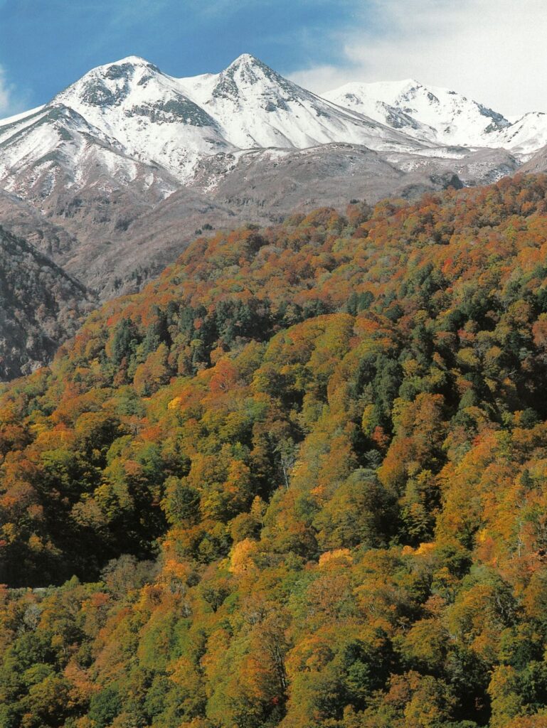
From left to right: Mt. Gozen, Mt. Kengamine, Mt. Onanjimine