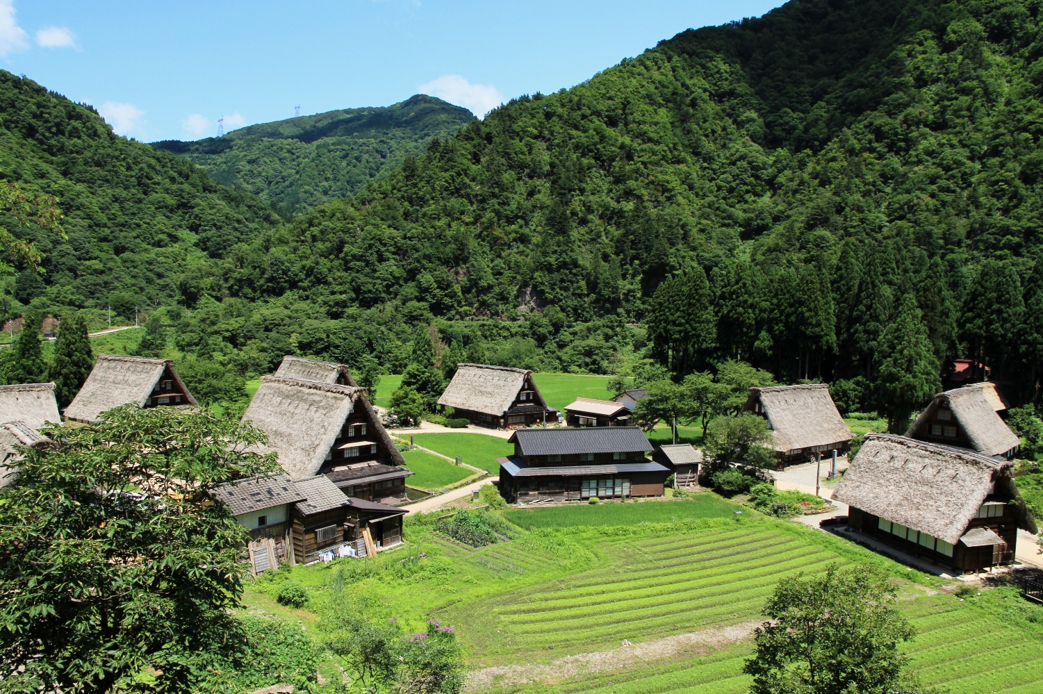
Located between Shirakawa-go and the Ainokura settlement, the village sits on a tongue-shaped river terrace projecting northward on the right bank of the Sho River, where the river turns from flowing northward to eastward. The terrace measures about 230 meters north–south and 240 meters east–west. The elevation is around 330 meters, with mostly flat terrain that slopes gently about 7 meters downward from the slightly higher southeast toward the northwest. Behind the southern edge of the terrace rises steep mountainous terrain. The preservation district encompasses the flat area consisting of residential plots and farmland. Notably, the southern mountainside behind the village is thickly forested with large trees such as beech, horse chestnut, and oak. Logging here is prohibited, and the forest is preserved as a snow-holding forest that helps prevent avalanches. As with other Gokayama settlements, the village site was deliberately chosen to avoid valleys prone to avalanches. Within the settlement lies the Suganuma Site, dating back to the Jomon period, indicating that people have inhabited this location since ancient times.
At present, the village is very small, with just five households (as of 2023). Records from 1889, however, show that Suganuma then had 13 households, ranking 9th in size among the 19 villages of former Kamitaira Village, and thus representing a settlement of average scale for the area.
Residential Plots
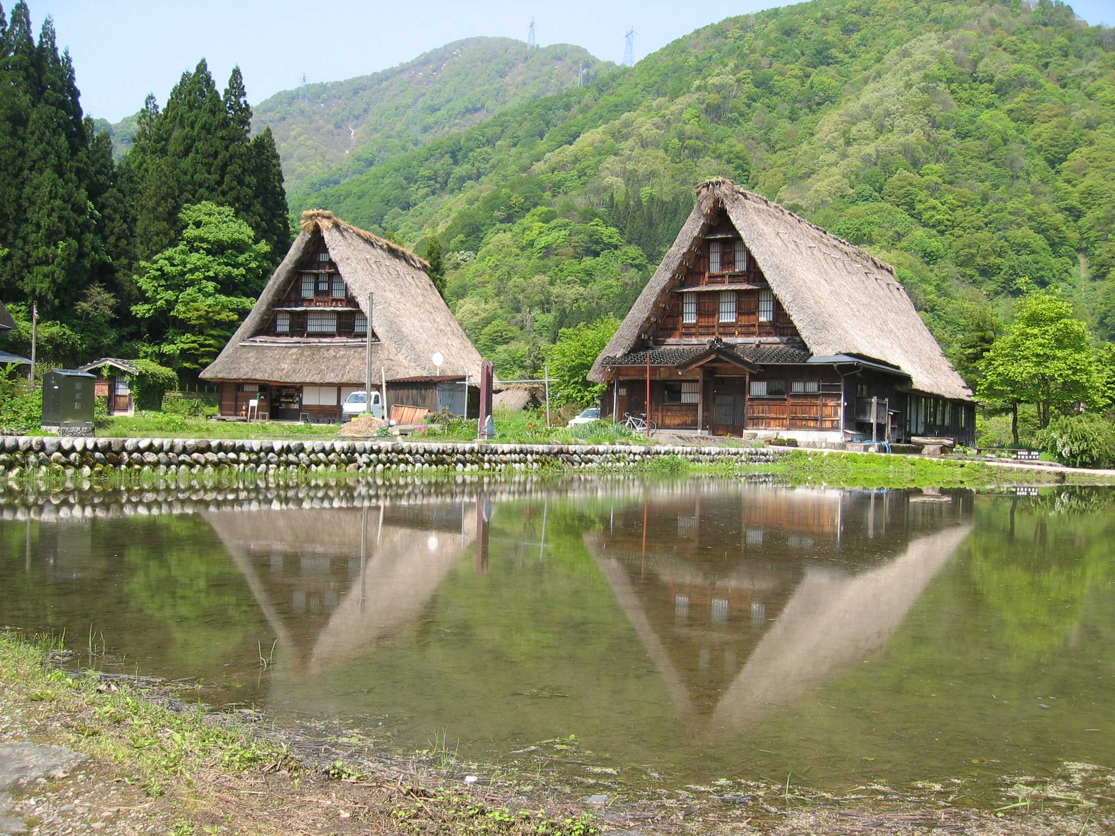
The residential plots are located toward the southeast of the terrace. While each house has auxiliary structures such as board-walled storehouses or earthen-walled warehouses, only a few are built adjacent to the main house; most are located at some distance. As a result, the main houses and their outbuildings do not form unified compounds. Each plot is relatively small and lacks fences or hedges, leaving them open.
The board-walled storehouses, which pose a high risk of spreading fire, are grouped together in clusters, concentrated in two locations within the village: on the west and north sides, which are upwind.
Farmland and Waterways
A consolidated rice field is found on the lower-lying northwest side of the village. In addition, there are small, irregular paddies and fields for cultivating vegetables and beans around the residential plots. These fields were originally used for mulberry cultivation but were converted into rice paddies in 1945, when irrigation water was diverted from the opposite bank of the river.
Traditional Buildings
Within the preservation district, nine gassho style houses remain. Of these, two date to the late Edo period (early to mid-19th century), six were built in the Meiji period, and one was newly constructed in 1925. This shows that gassho style houses continued to be built into the early 20th century.
In addition, Suganuma is the only village in the entire Gokayama area that preserves three thatched-roof board storehouses. There is also one two-story thatched house built in 1933. This style emerged around the Taisho period as a way to compensate for the low eaves of gassho style houses in heavy-snow regions, but it did not become established, as tile and sheet-metal roofing soon spread.
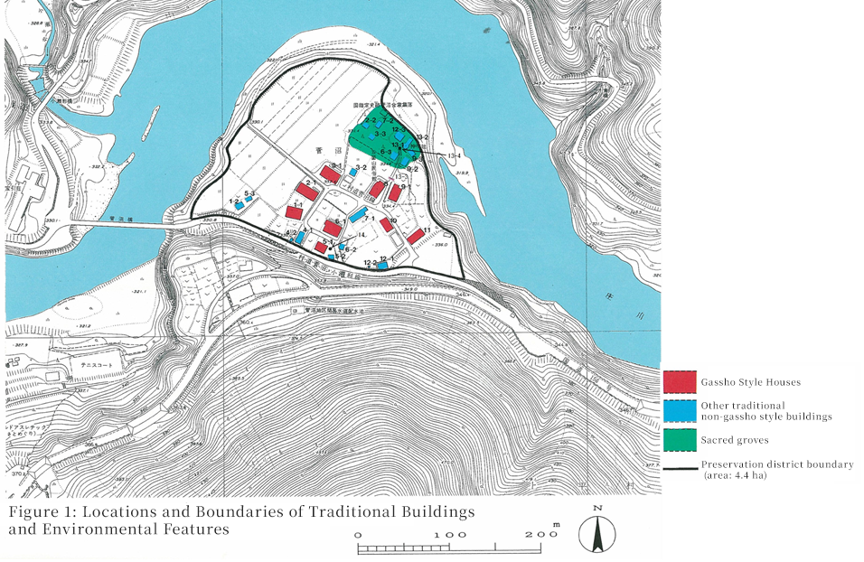
List of Preserved Properties within the Suganuma Traditional Buildings Preservation District, Nanto City
| Category | Number | ||||
|---|---|---|---|---|---|
| Of which, thatched-roof | |||||
| Traditional Buildings | Buildings | Main houses | Gassho style houses | 9 | 9 |
| Modified gassho style houses | |||||
| Non-gassho style houses | 3 | 1 | |||
| Subtotal | 12 | 10 | |||
| Other | Outbuildings | 14 | 3 | ||
| Religious buildings | 2 | ||||
| Subtotal | 16 | 3 | |||
| Total | 28 | 13 | |||
| Structures | Torii gates, stone lanterns, stone walls, stone steps, etc. | 2 | |||
| Environmental Features | Sacred groves, trees, hedges, waterways, etc. | 2 | |||
| Total | 32 | 13 | |||
History
Ancient and Medieval Periods
Jomon-period pottery unearthed from the river terrace where Suganuma Village now stands suggests that people were already living here in prehistoric times. In the medieval period, Jodo Shinshu Buddhism spread throughout the Gokayama region, leading to the formation of Shinshu-based villages. Tradition holds that Doshu, a disciple of Rennyo, resided in the nearby Akao settlement, making this area the cultural center of Gokayama at the time.
Early Modern Period
During the early modern period, Kamitaira Village, which included Suganuma, was under Kaga Domain control, and Suganuma belonged to Akao Valley in Etchu Gokayama. According to the 1619 land survey register, the assessed yield of the village was just over 53 koku, with washi paper and saltpeter recorded as its main products. Alongside small-scale rice cultivation, slash-and-burn fields were used to grow millet, foxtail millet, and buckwheat, supporting subsistence farming. The number of households was seven in the Kanbun era, increasing to nine in the Tenpo era, and by 1872 the village had 14 households, one tan of rice fields, nine cho of upland fields, and 83 cho of woodland.
Modern and Contemporary Periods
In 1889, the 70 villages of Gokayama were reorganized, and 19 of them, including Suganuma, became part of Kamihira Village. During the feudal period, one of Gokayama’s 13 ferry crossings was located in Suganuma. A cultural-era map places it near the present-day Suganuma Bridge. In 1879, the ferry was abolished and replaced by a suspension bridge. Around the same time, saltpeter production in Gokayama declined, while sericulture flourished under national policies promoting silk exports, becoming, together with washi paper, a major source of cash income. Soon, modernization began to reach Gokayama’s mountain settlements, including Suganuma, affecting politics, transportation, and industry. In the early Showa period, an automobile road was opened along the Sho River, hydroelectric development advanced, and new rice paddies were created, further modernizing the area. After World War II, however, from the 1950s through the 1970s, rapid economic growth in Japan led to urban migration, resulting in depopulation and an aging population in the village. In 1970, 14.5 hectares of mountain forest around Suganuma, including its thatch fields, were designated as a National Historic Site, marking the beginning of systematic efforts to preserve the gassho style settlement and its surrounding environment.
菅沼村.jpg)