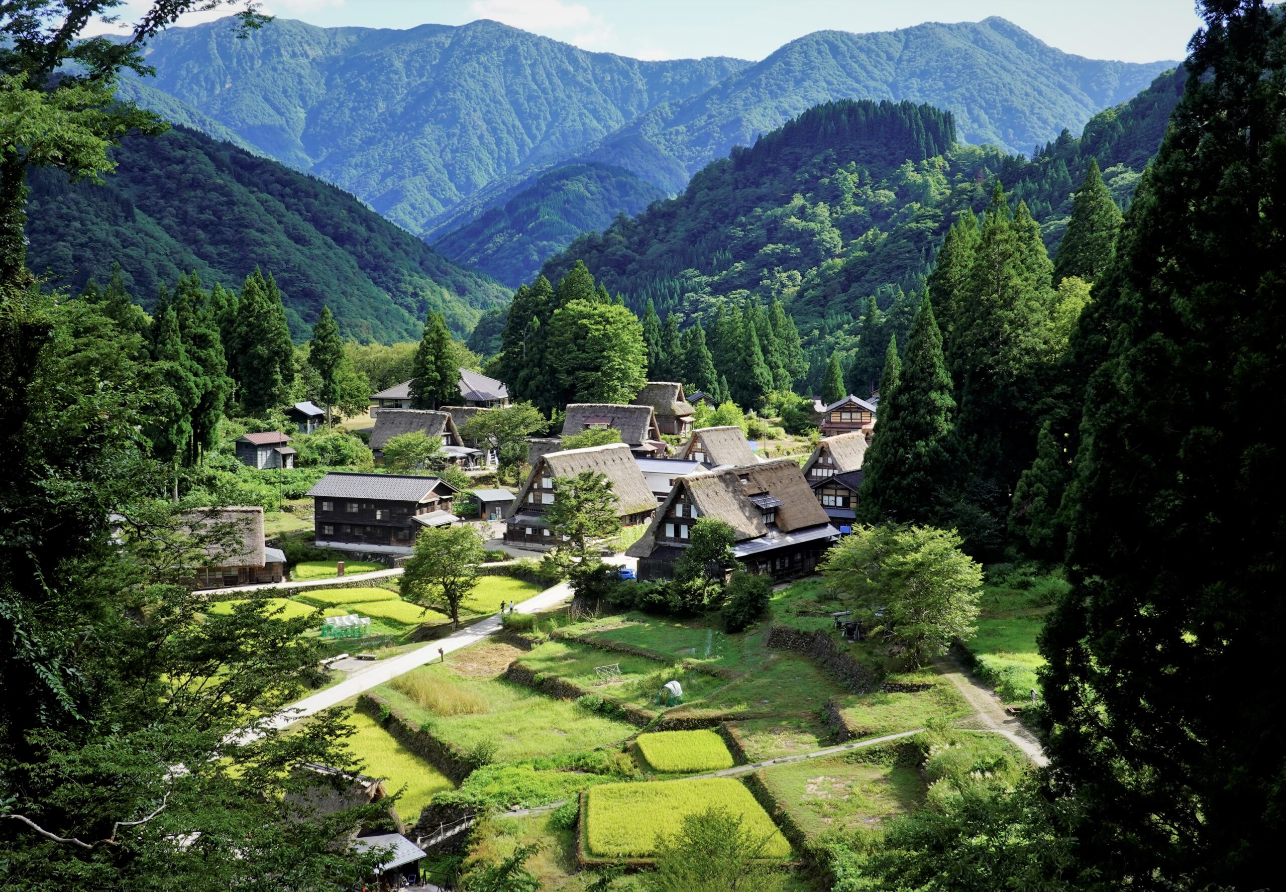
Ainokura Village lies on a river terrace set slightly above and away from the left bank of the Sho River. Surrounded by forest, the terrace sits at an elevation of around 400 meters. It stretches about 500 meters northeast to southwest and 200–300 meters southeast to northwest. On this flat land are the residential plots and farmland, with additional farmland extending onto parts of the slopes to the northwest and southeast. The preservation district centers on these residential and agricultural lands, but also includes sections of the wooded slopes behind the village, where large beech, horse chestnut, and oak trees are preserved as a snow-holding forest. Today the village has 16 households (as of 2023), but records from 1875 show 47 households, making it the fourth largest of the 25 settlements in former Taira Village.
Village Framework
The village framework is structured around the old main road (Johana), which runs roughly straight from northeast to southwest, climbing gently, with smaller village paths branching off to either side in curved lines that follow the terrain. These paths, dating back to the Edo period, are 2–3 meters wide. In addition, a 4-meter-wide automobile road was constructed in 1958, running through the center of the village. In the southern part of the settlement, the old main road bends westward, continuing as a zigzagging mountain path. This path, built in 1887, crosses steep mountain passes to reach the plains beyond, and remained an important regional route until recent decades.
Residential Plots
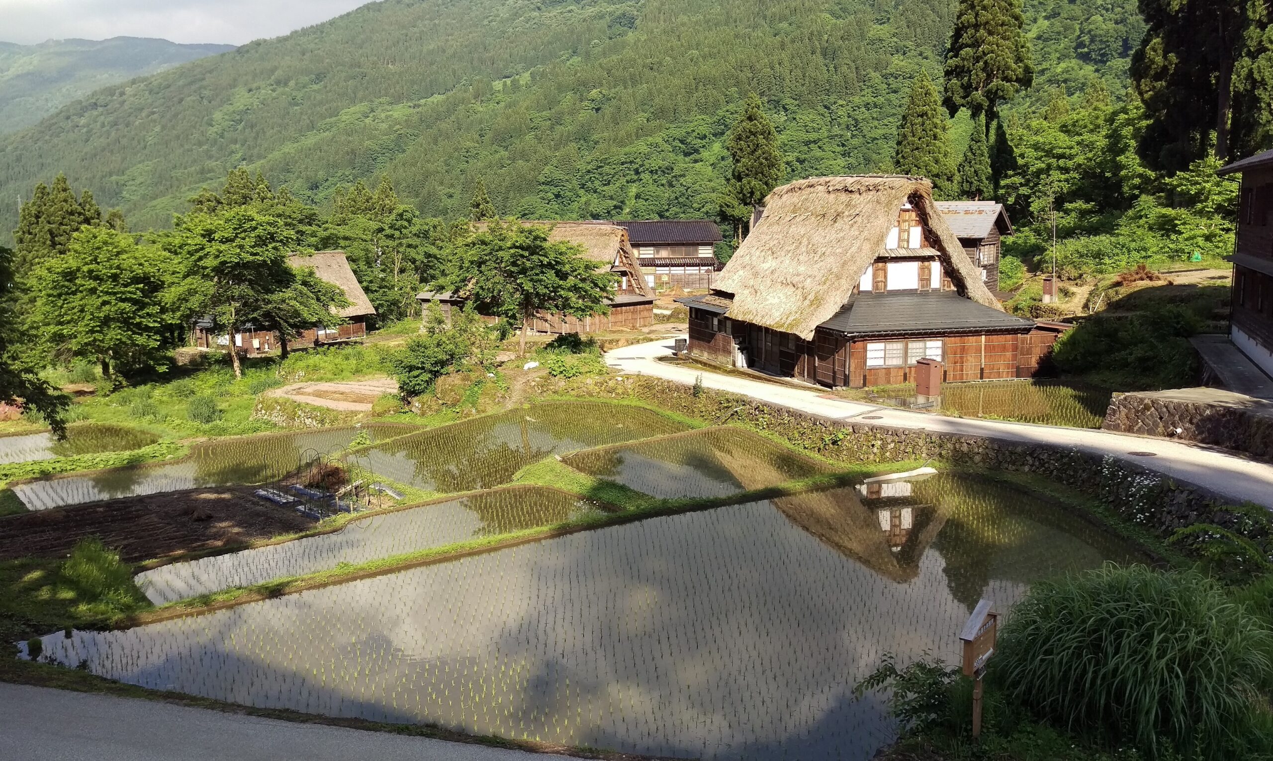
The residential plots have been leveled with stone retaining walls but remain open, without fences or hedges. Most plots are just large enough for the main house, with few homes having spacious front yards. Outbuildings include earthen-walled storehouses, board-walled storehouses, and separate toilets, though not every household has them. Board-walled storehouses and earthen storehouses are typically built at some distance from the main houses, as a precaution against fire.
Farmland and Waterways
Among the farmland, the rice paddies scattered around the residential plots are small and irregularly shaped, though somewhat larger consolidated paddies can be seen to the northeast of the village. Like the residential plots, these paddies are supported by stone retaining walls where needed. In the northwest, rice fields have also been created on sloping ground with tall stone walls; this area was once mulberry fields. The village’s main water source is stream water from the Sendodani valley to the southwest. From there, water is channeled along the western foot of the mountains through the settlement, supplemented by springs from the northwestern hillside, then divided into several waterways that irrigate the fields. Many houses are located on the western side, along these waterways, while another cluster of houses stands near the springs to the north. Because the eastern side of the village has poor water supply and is unfavorable for cultivation, it is instead home to a cemetery and the remains of a cremation ground.
Traditional Buildings
Within the preservation district, 20 gassho style houses remain. Most were built from the late Edo period through the Meiji period (early 19th to early 20th centuries). The oldest surviving examples are believed to date back to the 17th century, while three houses from the early 20th century show that gassho style continued to be built until that time.
Other thatched structures include Sonen-ji Temple (built in 1859), a rare thatched religious building with a hip-and-gable front entrance, and the Nishi Nenbutsu Dojo (built in the early Meiji period). Gokayama’s only surviving primitive gassho style (mata-date kayabuki) also remains here: a building in which the thatched gabled roof was placed directly on the ground. Though now used as a storage shed, it was once a dwelling. In addition, there is one two-story thatched house built around the Taisho period, a short-lived style that briefly appeared at that time.
At present, five former thatched houses have had their roofs replaced with tile or metal since the postwar era, and there are another seven houses that were built from the start with tile or metal roofs.
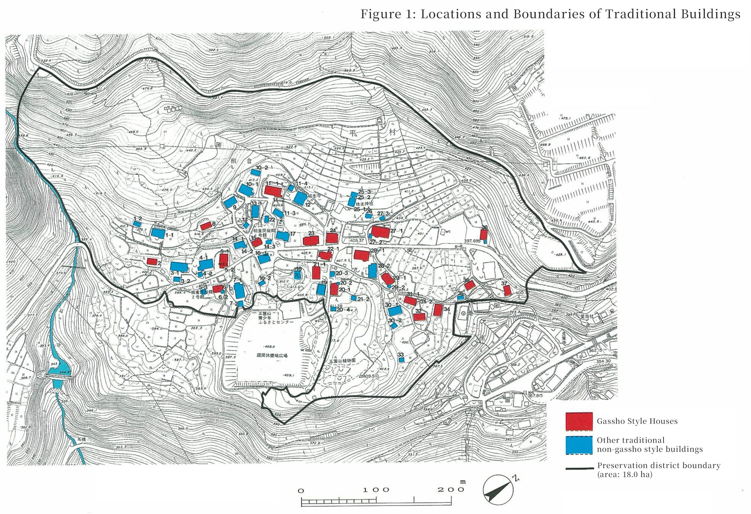
List of Preserved Properties within the Ainokura Traditional Buildings Preservation District, Nanto City
| Category | Number | ||||
|---|---|---|---|---|---|
| Of which, thatched-roof | |||||
| Traditional Buildings | Buildings | Main houses | Gassho style houses | 20 | 20 |
| Modified gassho style houses | 5 | ||||
| Non-gassho style houses | 7 | ||||
| Subtotal | 32 | 20 | |||
| Other | Outbuildings | 30 | 1 | ||
| Religious buildings | 5 | 2 | |||
| Subtotal | 35 | 3 | |||
| Total | 67 | 23 | |||
| Structures | Torii gates, stone lanterns, stone walls, stone steps, etc. | 5 | |||
| Environmental Features | Sacred groves, trees, hedges, waterways, etc. | 8 | |||
| Total | 80 | 23 | |||
History
Ancient and Medieval Periods
Archaeological finds such as pottery and other artifacts confirm that humans lived in this snowy region in prehistoric times, sustaining life with techniques adapted to the environment. In ancient times, the area around Ainokura developed as a site for mountain ascetic practices of the Tendai sect, centered on Ningyozan. Because of its remote, mountainous setting, legends also tell of Heike survivors seeking refuge here after their defeat. During the medieval period, Jodo Shinshu Buddhism spread throughout Gokayama, and villages of Shinshu adherents were established. In 1552, the name “Ainokura Tarojiro” appears among the signatures on a covenant from Zuigan-ji Temple (Shimonashi, Nanto City), confirming that a settlement already existed in Ainokura by that time.
Early Modern Period
In the early modern period, Taira Village, which included Ainokura, was under Kaga Domain control. Ainokura was part of the Shimonahi Valley in Etchu Gokayama. According to the 1619 land survey register, the village yield was just over 121 koku, with washi paper and saltpeter listed as its main products. Alongside limited rice cultivation, slash-and-burn fields were used to grow millet, foxtail millet, and buckwheat, providing subsistence food. The number of households increased from 15 in the Kanbun era to 42 in the Tenpo era, and by 1875, Ainokura had 47 households, 24 cho of fields, and 143 cho of forest land.
Modern and Contemporary Periods
In 1889, the 70 villages of Gokayama were reorganized into 25 villages, with Ainokura becoming part of Taira Village. Since the old road over Hotoge Pass leading to Johana Town was extremely difficult, a new road, the Michitani Shindo, was built in 1887, with Ainokura located at its entrance. This elevated Ainokura’s importance as a central village in the area. However, with the opening of an automobile road in the early Showa period that bypassed the settlement, Ainokura gradually lost its role as a transportation hub. After World War II, facing severe food shortages, land improvement projects were introduced, converting mulberry fields into rice paddies to achieve food self-sufficiency. Like other mountain villages, Ainokura was later affected by depopulation and an aging population due to rapid urban migration during Japan’s high-growth era. The local branch of the elementary school, opened in 1902, was eventually closed and merged with the main school as the number of children declined, marking a significant change in village life. In 1970, 42 hectares of mountain forest around Ainokura, including thatch fields, were designated a National Historic Site, initiating systematic preservation of the gassho style village and its surrounding environment.
相倉村.jpg)