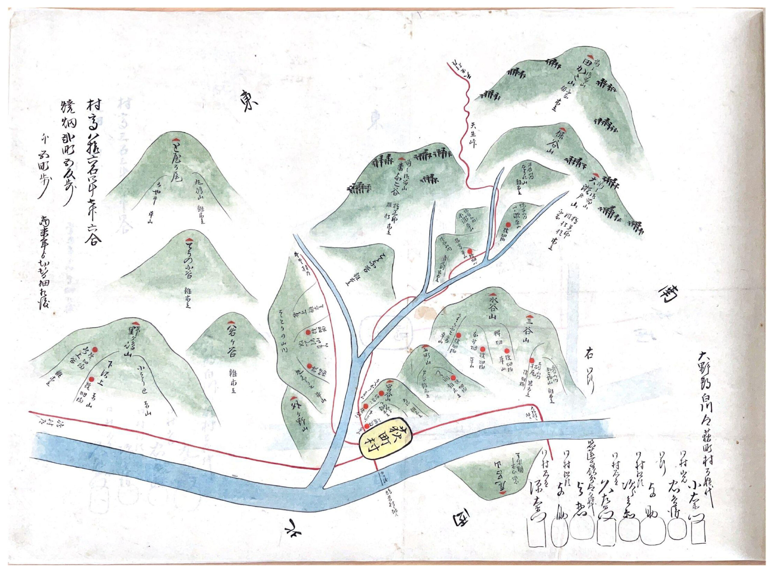
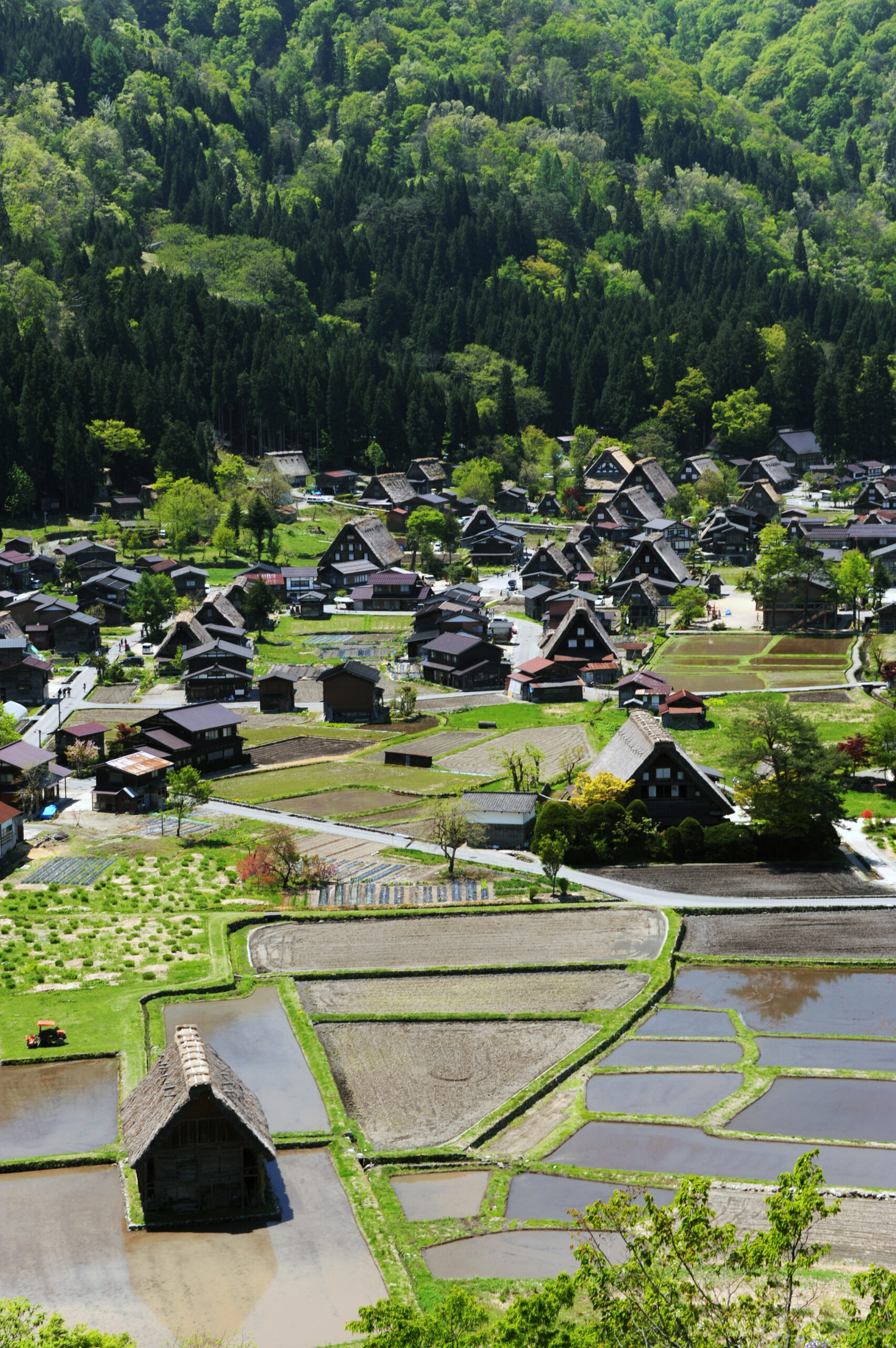
The central part of the village lies on a crescent-shaped river terrace on the east right bank of the Sho River, stretching about 1,500 meters north to south and up to 350 meters east to west. In addition, the village extends along the narrow valley of the Ushikubi River, which flows in from the east at the village’s northern end. On the opposite bank of the Sho River, there is also a small outlying settlement consisting of a single household. The terrace sits at an elevation of around 500 meters, with mostly flat terrain, though the eastern edge rises slightly toward the mountain foothills. The preservation area encompasses the majority of the residential and cultivated land of Ogimachi, along with part of the forested foothills to the east.
Among the three World Heritage villages, Ogimachi is the largest, with 128 households (as of 2023). According to records from 1876, Ogimachi then had 99 households, making it the largest among Shirakawa Village’s 23 settlements at that time.
Village Framework
The village framework consists of a 6-meter-wide north–south automobile road running through its center, combined with village paths 2–4 meters wide that weave like a net between fields and residential plots. While the village paths preserve the same form they had since the Edo period, the automobile road was established in 1890.
Residential Plots
Most residential plots are scattered among the fields, which forms the basic layout of Ogimachi. Today, however, some continuous rows of residential plots have developed along the main automobile road. The plots themselves are generally small and irregularly shaped, with varied relationships to the roads. On sloping land near the mountains, stone retaining walls have been built to level the ground. In most cases, boundaries are marked only by a strip of vegetation, a waterway, or farmland, without fences or hedges, creating an open atmosphere. Many houses also include outbuildings such as board-walled storehouses or drying huts. While toilets are often attached to the side of the main house, in many cases other outbuildings are located at some distance, within fields or forests. This arrangement reflects a consideration for fire safety, so that even if the main house were to burn down, storehouses and drying huts would not be lost.
Farmland and Waterways
Around the residential plots, small paddies and fields are scattered. Many of these are small-scale and irregular in shape, but somewhat larger, more consolidated farmland can be found to the north and south of the village. Today, vegetables and beans are mainly cultivated, though in the past mulberry trees for sericulture were also grown. The waterways that supply water to the rice paddies, like the village paths, run between residential plots and farmland, winding and branching into a net-like system. According to land records from 1888, some of these waterways had already been formed by the mid-Meiji period, while others were created later through waterway excavation and land improvement projects up until the mid-Showa period. Many of the earlier waterways drew from natural springs, which once served widely as sources of drinking water, household water, and irrigation. These springs and waterways played an important role in shaping the traditional spatial organization of the village, including the layout of houses and rice fields. Later, in 1926, the Omata diversion channel was developed, expanding the rice fields within the village, and as a result, the waterway network extended even further.
Traditional Buildings
The gassho style houses of Ogimachi are built with their ridgelines running north–south. Viewed from the elevated northern side of the village, the triangular gable ends of the houses all face the same direction, creating a striking landscape. This arrangement allows the thatched roofs, which face east and west, to receive sunlight evenly, helping the wet thatch dry more easily—an intentional adaptation to the heavy snowfall and damp climate. The sight of these similarly constructed houses aligned in orderly clusters forms a distinctive and highly memorable village landscape. Within the preservation district, there are 59 gassho style houses. Including the main hall of Myozen-ji Temple, which is not a private residence but built in the same style, the total becomes 60. Most of these houses were constructed between the late Edo period and the Meiji period (from the early 19th to early 20th centuries). The oldest surviving examples are thought to date from the mid- to late 18th century, while the newest were built in the early 20th century, showing that gassho style houses continued to be built until that time.
-scaled.jpg)
List of Preserved Properties within the Shirakawa Village Ogimachi Traditional Buildings Preservation District
| Category | Number of Items | ||||
|---|---|---|---|---|---|
| Of which, thatched-roof | |||||
| Traditional Buildings | Buildings | Main Houses | Gassho Style Houses | 59 | 59 |
| Modified Gassho Style Houses | 1 | ||||
| Non-Gassho Style Houses | 7 | ||||
| Subtotal | 67 | 59 | |||
| Other | Outbuildings | 46 | 46 | ||
| Religious Structures | 4 | 4 | |||
| Subtotal | 50 | 50 | |||
| Total | 117 | 109 | |||
| Structures | Torii gates, stone lanterns, stone walls, stone steps, etc. | 11 | |||
| Environmental Features | Sacred groves, trees, hedges, waterways, etc. | 8 | |||
| Total | 136 | 109 | |||
History
Ancient Times
Pottery, stone tools, and other artifacts unearthed throughout Shirakawa Village indicate that human life in this area dates back about 7,000 years, to the early Jomon period. Although little is known about the circumstances surrounding Shirakawa Village in ancient times, in the late Heian period the name Hida no Kuni Shirakawa-go first appears in the diary Gyokuyo of Kujo Kanezane, in an entry from 1176, marking its recognition. Local tradition also holds that after the Heike forces were defeated by Kiso Yoshinaka at the Battle of Kurikara Pass in 1183, survivors fled and sought refuge in Shirakawa-go.
Medieval Period
Shirakawa-go originally developed as a base for Shugendo practices centered on Mt. Hakusan and came under the control of Choryu-ji, a Tendai temple. In the mid-13th century, when Kanenbo Zenshun, a disciple of Shinran, established a Jodo Shinshu preaching hall in Hatogaya, Pure Land Buddhism spread widely in the Hida region, and Shirakawa-go came under its influence. From this period, place names such as Hatogaya and Iijima appear in records, suggesting that Ogimachi was also formed around this time. In the mid-15th century, during the Muromachi period, the Uchigashima clan from Shinano Province extended its control over Shirakawa-go. For the next 110 years, the area was ruled by four generations of the clan, during which time a branch castle was established in Ogimachi, contributing to the village’s further development.
Early Modern Period
In 1585, a great earthquake destroyed the Uchigashima clan’s castle at Kaerikumo, wiping out their rule. Shirakawa-go then came under the control of the Kanamori clan, lords of Hida Takayama Castle. After six generations and 107 years of Kanamori rule, the Hida area became a direct territory of the Tokugawa shogunate in 1692. At that time, Ogimachi was divided between the shogunate’s administrators and Myozen-ji, a Jodo Shinshu temple in Takayama. The village is thought to have had around 30 households in this period. It was also around this time that sericulture and the production of saltpeter became active industries. Both required large spaces and significant labor, and as wealth accumulated, houses grew larger, and attic spaces began to be utilized. This period is believed to have seen the formation of the gassho style houses recognizable today.
Looking at the changes in the number of households in Ogimachi during the Edo period, there were 52 in 1730 and 58 in 1841, but by 1853 the number had increased significantly to 80. This growth is thought to reflect the expansion of commercial production in the late Edo period.
Modern and Contemporary Times
In 1889, the 41 villages of Shirakawa-go were reorganized, with 23 forming Shirakawa Village in the north and 18 forming Shokawa Village in the south. Ogimachi thus became part of Shirakawa Village. At the beginning of the Meiji period, Ogimachi had 99 households and about 700 residents, making it the central settlement of the village.
During the Meiji period, the number of households and population in Ogimachi increased gradually, supported by the growth of sericulture. By 1937, just before the Pacific War, the number of households had reached 145—nearly double that of the late Edo period. After the war, in 1955, the village experienced a temporary surge to 332 households. This sharp increase was due to the construction of three dams during the period of rapid economic growth, which brought in large numbers of construction workers as well as resettled residents from six villages submerged by the dams. Once the dam projects were completed, however, and with the simultaneous outmigration of people to urban areas, depopulation became pronounced. By 1965, the number of households had sharply declined to 192 (150 excluding the Togano district).
Amid this decline, Ogimachi remained one of the few places where gassho style houses survived in relatively good condition. Recognizing the need for preservation, villagers formed the Association to Protect the Natural Environment of Shirakawa-go Ogimachi in 1971, followed by the drafting of a Residents’ Charter. These efforts expanded beyond the houses to include rice fields, farmland, old roads, and forests as part of the historical landscape. As a result, when the Law for the Protection of Cultural Properties was revised in 1975 to establish the system of Important Preservation Districts for Groups of Traditional Buildings, Shirakawa Village enacted local ordinances the following year, designating Ogimachi for preservation and beginning formal conservation planning. In 1976, Ogimachi was officially selected as an Important Preservation District for Groups of Traditional Buildings.
-scaled.jpg)